JAMBI PROVINCE
Sumatra, Indonesia
Map source: People Group location: IMB. Map geography: ESRI / GMI. Map design: Joshua Project⁴⁹.
Introduction
Components of net change in tree cover in Jambi.
Disturbance represents areas that experience losses and gains between 2000 and 2020 ⁵¹.
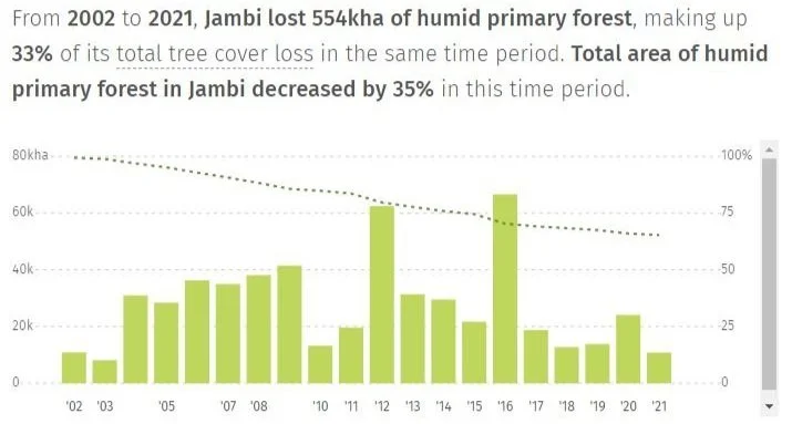
Primary forest loss in Jambi, Indonesia. ⁵¹.
Tree cover loss in Jambi, Indonesia ⁵¹.
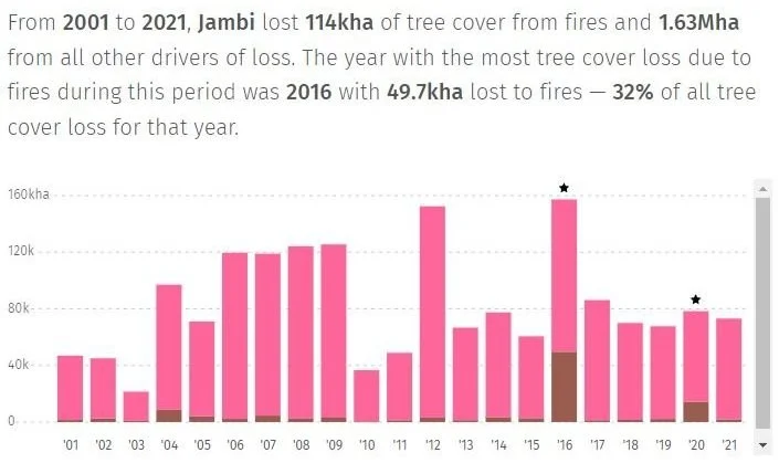
Tree cover loss due to fires in Jambi, Indonesia ⁵¹.
REDD+ Implementation in Jambi Province
Created by the United Nations Framework Convention on Climate Change “UNFCC”.
Aim: To assist the implementation of activities by national governments to reduce human pressure on forests that result in greenhouse gas emissions at the national level, but as an interim measure also recognizes subnational implementation⁵².
Jambi Province was selected as a pilot for province-wide emissions reduction programs⁵³ under the BioCarbon fund to boost conservation, sustainable management of forests and enhancement of forest carbon stocks .
Together with the Ministry of Environment and Forestry it has:
Established a new ministerial taskforce to accelerate the recognition of traditional land rights.
Developed a province-wide results-based emissions reduction program, in close collaboration with East Kalimantan’s government ⁵⁴.
Results-based Emissions Reduction Program
Flora and Fauna International recognises that communities should have a benefit and a responsibility of their forest areas. They help the district get land tenure rights from the Ministry of Environment and Forestry.
Furthermore, Payment for Ecosystem Services provides incentives when farmers or landowners manage their forest land sustainably. This allows farmers and landowners to turn to other sources of income.
Hence, reducing the dependence of the community on natural forest resources for income⁵⁵.
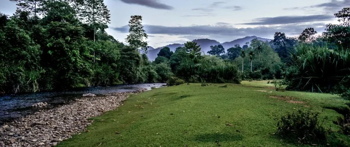
Bujang Raba, Jambi⁵⁶
The community is managing this garden in Bujang Raba, Jambi, and developing it into multi-tiered agroforestry⁵⁶. The model hopes to provide sustainable revenue for five villages, producing rubber, coffee, cinnamon, cardamom and ‘dragon’s blood’ (jernang) – while keeping the primary forest intact.
-
Ministry of Environment and Forestry
Role: Implementing AgencyMerangin District Planning Agency
Local Government
Role: Provide funds to 22 villages to increase their motivation in managing the forests. -
United Nations Framework Convention on Climate Change (UNFCC)
Role: Creation of REDD+ and overall management of the program.Fauna and Flora International
International Conservation Charity (NGO). Patronised by the English royal family
Role: Supports local communities clarify land tenure. Requests permit and licensing with the Ministry of Environment and Forestry.
Vision: Long-term community-led sustainable forest management. -
BioCarbon Fund: Initiative for Sustainable Forest Landscapes
Role: Funds the provincial governments and communities around critical forest areas.
(Mainly) Funded by:
Germany, Switzerland, United Kingdom, USAWorld Carbon Partnership Facility
Role: Managing the Results-Based Payments from BioCarbon Fund and Government of Indonesia. -
World Agroforestry Centre
Role: Provides Agroforestry Research
Enables the governments, development agencies and farmers utilize the power of the trees to make farming and livelihood more environmentally, socially and economically sustainable. -
Merangin District Planning Agency
Local Government
Role: Provide funds to 22 villages to increase their motivation in managing the forests.
Forest Management Unit
Role: Support local communities to market their products and promote the rehabilitation of critical degraded areas through community-based restoration techniques.District Community Empowerment an Village Government Service (DPMPD)
Role: Facilitate the establishment of fire-free village and community fire prevention and management team. Made up of volunteers from the villageManggala Agni
Role: Forest fire fighters and preventers across Indonesia
Agencies
FOREST MANAGEMENT
MERANGIN DISTRICT
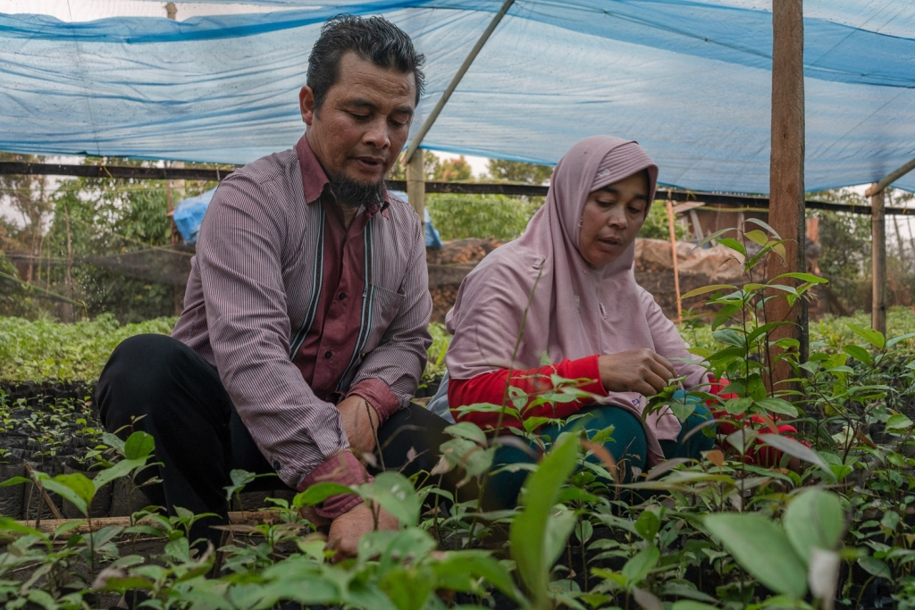
Nursery owned by farmer group in Jambi. Photo: Fauzan Ijazah/World Bank ⁵⁸
Community manages for 40,000 ha of High Conservation Value forests through Village Forest (Hutan Desa) and Customary Forest (Hutan Adat) licenses to villages and indigenous people.
License guarantee rights of forest use. 35 years are the strongest legal tenure instrument for communities. Forests will be community managed and cannot legally be converted and forest resources cannot be illegally harvested, allowing communities to take responsibility for their customary forests while benefiting from legal access to life-supporting forest resources⁵⁷.
Under the Green Growth Plan, communities can gain income from forests by:
Harvesting non-timber forest products such as honey and cinnamon
Practicing ecotourism and providing ecosystem services.
The Forest Management assisted to distribute cacao and cardamom seedlings grown by the village’s nursery.
These were done in their community forests as long as they replanted their cleared trees⁵⁷.
Announcement of Customary Forest in Sepulut Village. 2016 ⁵⁹


